Solar Thermal Potential
The solar thermal potential is determined through a multi-criteria geospatial analysis to identify suitable land for solar thermal system deployment. This process, conducted using QGIS, involved the systematic exclusion of unsuitable areas, including but not limited to parks, infrastructure, designated protected zones, and existing buildings. Furthermore, an explicit overlay with Natura 2000 areas was performed to rigorously ensure that all legally protected land was unequivocally excluded from consideration for potential solar thermal installations.
Using QuickOSM, QGIS plugin, land use layer is downloaded. Within the land-use layer, all land areas unsuitable for the construction of solar collector systems were removed from the attribute table. Suitable land areas are those that are not parks, transportation infrastructure, protected areas, and do not have existing buildings. After that, the land-use layer was overlaid with the Natura 2000 layer to eliminate all protected areas. With this we identified suitable areas for solar thermal.
For the identified suitable land areas, the surface area of each parcel was calculated using the Field Calculator and the "$area" command in the attribute table of the final layer. This step allows quantification of the available surface area for the installation of solar collectors.
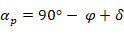
To optimize the installation of solar collectors, the PVGIS was used to determine the optimal tilt angle of solar collectors for the City of Vukovar. The optimal tilt angle is (β) 36°. To avoid shading between rows of collectors, the distance between rows must be calculated. This distance is determined for the smallest daily angle between the horizon and the Sun during the shortest day of the year (winter solstice). The formula for calculating this angle is:
 (1)
(1)
where:
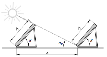
 – Angle between the horizon and the Sun during the winter solstice, 21.14, [°].
 – Local latitude, 45.35161°, [°].
 – Solar declination (tilt during the winter solstice), 23.44°, [°].
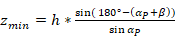
Considering the optimal tilt angle of solar collectors and the standard dimensions of solar collectors ( ), the required distance between rows of collectors is calculated as follows:
 (2)
(2)
where:
 – Required distance between rows of collectors, [m].
 - Height of the collector, [m].
 – Optimal tilt angle of solar collectors, 36°, [°].
The surface area of solar collectors was calculated considering the effect of shading and a maximum land coverage condition of 90%. The formula for calculating the surface area of solar collectors is:
 (3)
(3)
where:
 – Surface area of solar collectors [m²],
 – Total land area [m²],
 - Height of the collector [m],
 – Width of the collector [m],
Once suitable land areas in the City of Vukovar were defined, the next step involved calculating the maximum possible surface area of solar collectors for each parcel. By applying the appropriate formula in the Field Calculator in QGIS, using the previously calculated footprint areas of suitable land parcels, the maximum possible surface area of solar collectors for each land parcel was determined. This estimation accounts for installation conditions and the spatial characteristics of individual parcels.
Flat-plate solar collectors with an Efficiency of approximately 48% were assumed. This efficiency reflects the ability of collectors to convert solar radiation into thermal energy. According to PVGIS data, the Annual solar radiation for the City of Vukovar is 1.597,53 kWh/m². Based on this information and the assumed efficiency, the specific thermal energy production,  , potential was calculated as 766,81 kWh/m² for flat-plate solar collectors.
By multiplying the specific thermal energy production potential by the available collector surface area for each parcel, the annual thermal energy production,  , for each parcel was obtained.
 (4)
(4)
Assuming the deployment of flat-plate solar collectors with a conversion efficiency of 48%, the total annual thermal energy production for each identified land parcel was then quantitatively estimated based on its calculated effective collector surface area and the incident solar radiation.